Updates to Google Maps add more detail to countries and city streets

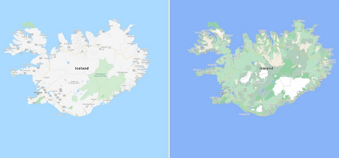
Google has been continually improving the Google Maps app and today some new visual improvements for the app were announced. The changes add more detail to the imagery giving the user more information when taking a virtual drive through an area, or when planning a visit. One update to Google Maps brings a more natural look to an area being viewed on the app. As Google notes, "Exploring a place gives you a look at its natural features—so you can easily distinguish tan, arid beaches and deserts from blue lakes, rivers, oceans and ravines. You can know at a glance how lush and green a place is with vegetation, and even see if there are snow caps on the peaks of mountaintops."
Google adds more detailed imagery to Google Maps
This can be achieved through Google's high-definition satellite imagery that covers 98% of the global population. Add to that a new color-mapping algorithmic technique and Google Maps becomes more vibrant showing better details and more realistic colors that make it easier to understand the environment of a specific area. The color mapping technique starts by using a computer to pick out natural features found in satellite images looking specifically for "arid, icy, forested, and mountainous regions." These areas are analyzed and assigned different colors using the HSV color model. As an example, Google says that it would use dark green to signify an area with a densely covered forest. A lighter shade of green could be used to show an area of "patchy shrubs."

The old look is at left with the updated more detailed image on the right
The update to Google Maps leaves the app with "one of the most comprehensive views of natural features on any major map app—with availability in all 220 countries and territories that Google Maps supports. That’s coverage for over 100M square kilometers of land, or 18 billion football fields!" Google states that the "This update is visible no matter what area you’re looking at—from the biggest metropolitan areas to small, rural towns.
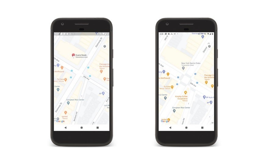
Besides helping users visualize the natural conditions of a country and region, Google Maps will soon be delivering more detailed street information that not only shows the correct scale of a road but will also include the correct shape of it. Correct placements of sidewalks, crosswalks, and pedestrian islands will appear, important information for those in a wheelchair or pushing a stroller. It also is helpful to people taking solo walks due to the pandemic. In the coming months, the detailed street maps will roll out in New York, London and San Francisco with more cities added over time.

The image on the right contains a more detailed look of the city streets which are shown to scale and with pedestrian islands and more
The more natural images will start rolling out this week and can be viewed by zooming out on the app. Google Maps Platform developers will soon be able to use the new look for their maps. You can install Google Maps on your iOS device from the App Store and download it on your Android device by snagging it from the Google Play Store.
As Google continues to add more and more features to Maps, Apple is also buy working on its mapping app. In June 2018, Apple announced that it was building Apple Maps from scratch and would use its own mapping data instead of using third-party providers like TomTom. Specially designed Apple vehicles have driven 4 million miles to capture more detailed and refined views for users. While Apple tries to catch up with Google, the latter continues to be the unquestionable leader in navagation for mobile device users.


Things that are NOT allowed: