Google Maps serves billions of users worldwide, and to keep them happy, Google regularly rolls out updates. Recently, it introduced redesigned pins, new colors, and a sleeker bottom bar. But let’s be honest, looks aren’t everything. The real value comes from content, and this next update focuses on just that – making the app even better for diving into both the world’s past and present.
Historical imagery, expanded coverage and enhanced quality
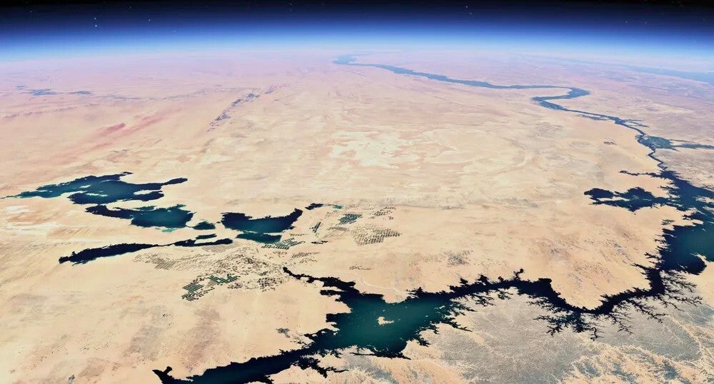
Google is rolling out some exciting updates to Earth and Maps that are set to make exploring the world even cooler. You will soon be able to dive into historical imagery on Google Earth, get a lot more Street View coverage, and see sharper satellite pics thanks to AI.
One of the standout features in this update is the addition of historical imagery to Google Earth. This lets users virtually travel back in time to see how landscapes have changed over the years, offering a visual story of how human activity and climate change have shaped the world.
San Francisco then and now: a snapshot from 1938 versus 2022. | Image credit – Google
In some places, the imagery goes back as far as 80 years. Major cities like London, Paris, and Berlin are part of the mix, with snapshots dating back to the 1930s. The feature works on both the web and mobile versions of Google Earth.
Google is also beefing up Street View with a major update, adding new imagery to nearly 80 countries, some of which are getting covered for the first time. Places like Bosnia, Namibia, Liechtenstein, and Paraguay are joining the list. On top of that, countries like Australia, Argentina, Brazil, Denmark, Spain, Japan, New Zealand, Rwanda and many more are seeing expanded coverage as part of the update.
It is 2024, so of course, Google is not leaving AI out of the mix. Along with adding more places to explore, Google is using AI to make satellite images in Earth and Maps even clearer. With its new AI model, Cloud Score Plus, Google is cleaning up satellite images by getting rid of things like clouds, mist, and haze, making the views much sharper and more detailed.
Recommended Stories
Starting this week, you will see a brighter, more vivid globe, thanks to Google’s new cloud-removal tech. | Image credit – Google
As a regular Google Maps user who loves exploring the world from home with Street View when travel isn’t an option, I think this update is really exciting. The chance to roam the streets of previously uncharted countries is fantastic, and the historical imagery adds an intriguing twist. Who knows? You might stumble upon some new knowledge along the way, and that’s always a win.
Did you enjoy reading this article?
There's more to explore with a FREE members account.
Tsveta, a passionate technology enthusiast and accomplished playwright, combines her love for mobile technologies and writing to explore and reveal the transformative power of tech. From being an early follower of PhoneArena to relying exclusively on her smartphone for photography, she embraces the immense capabilities of compact devices in our daily lives. With a Journalism degree and an explorative spirit, Tsveta not only provides expert insights into the world of gadgets and smartphones but also shares a unique perspective shaped by her diverse interests in travel, culture, and visual storytelling.
A discussion is a place, where people can voice their opinion, no matter if it
is positive, neutral or negative. However, when posting, one must stay true to the topic, and not just share some
random thoughts, which are not directly related to the matter.
Things that are NOT allowed:
Off-topic talk - you must stick to the subject of discussion
Offensive, hate speech - if you want to say something, say it politely
Spam/Advertisements - these posts are deleted
Multiple accounts - one person can have only one account
Impersonations and offensive nicknames - these accounts get banned
Moderation is done by humans. We try to be as objective as possible and moderate with zero bias. If you think a
post should be moderated - please, report it.
Have a question about the rules or why you have been moderated/limited/banned? Please,
contact us.


Things that are NOT allowed: