Google Maps and Search are expanding their wildfire tracking features to 15 new countries across Europe and Africa, bringing the total to 22 countries where users can access this potentially life-saving information. This update comes after the successful implementation of wildfire boundaries and information in regions like the US, Canada, Mexico, and Australia.
The newly added countries include popular tourist destinations and regions prone to wildfires:
Andorra
Bosnia & Herzegovina
Croatia
Cyprus
France
Greece
Italy
Kenya
Monaco
Montenegro
Portugal
Rwanda
Slovenia
Spain
Turkey
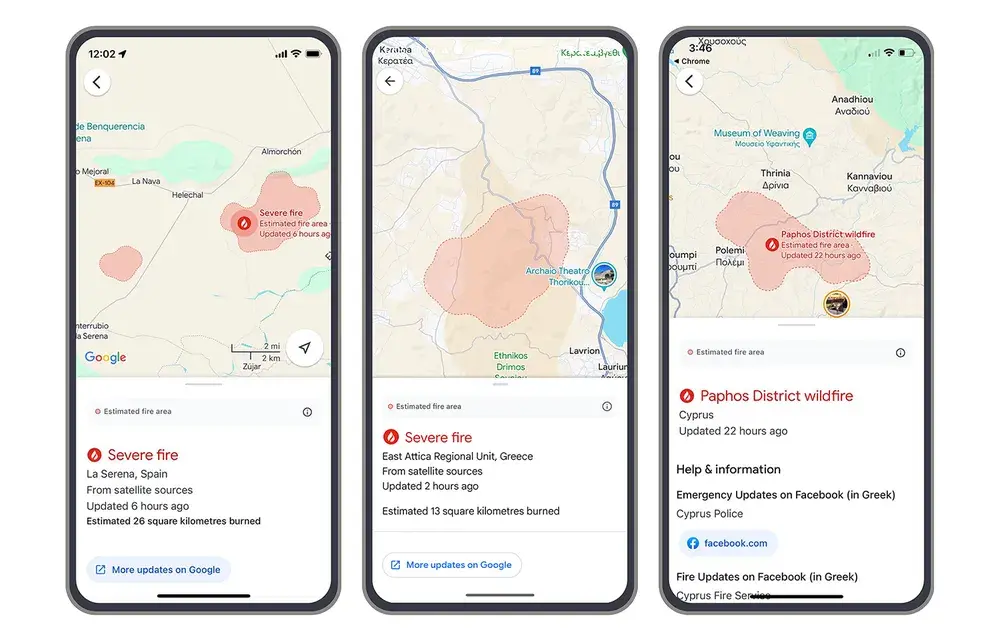
Google's AI-powered wildfire tracking has already proven its worth by mapping over 40 wildfires in Southern Europe this summer. By providing wildfire boundaries and information in Search and Maps, as well as sending out notifications, Google aims to complement existing on-the-ground efforts to help people access crucial information and stay safe during wildfire events.
Wildfires tracked this summer | Image credit — Google
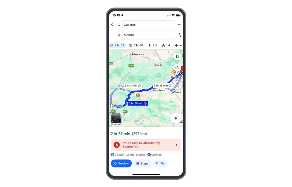
In just the first week of July, an estimated 1.4 million people utilized Google's wildfire information, demonstrating the significant impact this feature can have in regions experiencing wildfires. Users in affected areas can receive alerts through notifications on their phones, as well as while using driving directions in Google Maps.
Recommended For You
This expansion of Google's wildfire tracking features is a welcome development, providing valuable information to a wider range of users and potentially contributing to greater safety and awareness during wildfire events. By leveraging AI and existing infrastructure, Google continues to demonstrate its commitment to utilizing technology for the greater good.
Wildfires overlaid on Google Maps driving directions | Image credit — Google
The inclusion of Kenya and Rwanda in the list of countries with wildfire tracking is particularly noteworthy, as these regions often face unique challenges in terms of wildfire management and access to information. By expanding its wildfire tracking capabilities to these countries, Google is helping to address a critical need and potentially saving lives.
Furthermore, the ability to access wildfire information through Google Maps and Search can be especially beneficial for travelers, as it allows them to stay informed and plan their routes accordingly. By providing real-time updates on wildfire locations and boundaries, Google can help travelers avoid dangerous areas and make informed decisions about their itineraries.
Overall, Google's expansion of wildfire tracking features is a significant step forward in the fight against wildfires. By providing accessible and up-to-date information to a wider audience, Google is empowering people to stay safe and protect their communities.
Six-month unlimited plan is now 57% off
$90
$210
$120 off (57%)
Mint Mobile is now allowing you to get whichever plan you like for either three, six, or 12 months for just $15/mo. If you go for the six-month unlimited service, for instance, you'll now have to pay just $90 upfront instead of $210.
Johanna Romero is a Senior News Writer at PhoneArena, covering mobile technology news across Android, iOS, wearables, and the Google ecosystem she knows best. Drawing on 15 years in IT and tech support from 2007 to 2022, she brings a user-friendly eye for the practical features and lesser-known tricks readers care about. Google named her an official #TeamPixel member in 2022, and she also reviews the latest devices on her YouTube channel, JoJo the Techie.
A discussion is a place, where people can voice their opinion, no matter if it
is positive, neutral or negative. However, when posting, one must stay true to the topic, and not just share some
random thoughts, which are not directly related to the matter.
Things that are NOT allowed:
Off-topic talk - you must stick to the subject of discussion
Offensive, hate speech - if you want to say something, say it politely
Spam/Advertisements - these posts are deleted
Multiple accounts - one person can have only one account
Impersonations and offensive nicknames - these accounts get banned
To help keep our community safe and free from spam, we apply temporary limits to newly created accounts:
New accounts created within the last 24 hours may experience restrictions on how frequently they can
post or comment.
These limits are in place as a precaution and will automatically lift.
Moderation is done by humans. We try to be as objective as possible and moderate with zero bias. If you think a
post should be moderated - please, report it.
Have a question about the rules or why you have been moderated/limited/banned? Please,
contact us.


Things that are NOT allowed:
To help keep our community safe and free from spam, we apply temporary limits to newly created accounts: