Google has funded FireSat, which is a satellite constellation aimed to track, detect, and maybe even help prevent wildfires from spreading. The first satellite from the program is expected to launch in early 2025, and Google is getting involved.
Google has been helping with alerting users about nearby wildfires since 2020, and it used Google Maps and Search services to alert people. The Mountain View tech giant has been mapping the wildfires in detail, keeping people aware of potential dangers. Also, the tech giant sends notifications and instructions on how to stay safe.
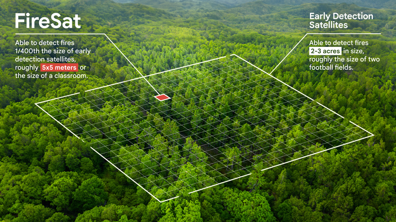
Also, Google has invested $13m into the Earth Fire Alliance initiative that aims to detect and track wildfires the size of a classroom within 20 minutes. The Earth Fire Alliance is a non-profit organization that was created to launch the FireSat constellation.
Google is not only financially supporting FireSat though. Google Research will also contribute to the project, and the entire platform will take advantage of AI tech for a better way to monitor and manage wildfires.
Image Credit - Google Research
The Google Research team will insert relevant data into Machine Learning (ML) technology. This will help develop AI-backed enhancements and improvements that can help detect wildfires when they are small (and thus, there's more chance to react and get them under control before they spread).
You may know that wildfires are pretty hard to detect, and often, you can also get false alarms. What we have right now in terms of satellite imagery used for wildfire detection has infrequent updates and provides low-res images.
This pretty much means wildfires can go undetected until they become as big as a football field. Google and the FireSat constellation aim to address these issues and speed up wildfire detection.
The first satellite from the group is expected to launch early next year. According to the project, the constellation would consist of 50 satellites in low-earth orbit.
These satellites will have infrared sensors to detect small fires. It's possible the constellation may help detect a fire as small as 5 by 5 meters (about the size of a regular classroom).
Recommended Stories
Also, FireSat should be able to give people accurate and actionable info about where the fire is, how big it is, and what is its intensity. Real-time updates can help agencies take care of wildfires before they become dangerous and become a threat to life and property.
I find this initiative very inspiring and I'm happy that Google is involved with helping such initiatives. The tech giant is in an ideal position (like other tech giants on the market) to really help improve how we handle such conditions. So, kudos to Google for that one!
Create a free account and join our vibrant community
Register to enjoy the full PhoneArena experience. Here’s what you get with your PhoneArena account:
Izzy, a tech enthusiast and a key part of the PhoneArena team, specializes in delivering the latest mobile tech news and finding the best tech deals. Her interests extend to cybersecurity, phone design innovations, and camera capabilities. Outside her professional life, Izzy, a literature master's degree holder, enjoys reading, painting, and learning languages. She's also a personal growth advocate, believing in the power of experience and gratitude. Whether it's walking her Chihuahua or singing her heart out, Izzy embraces life with passion and curiosity.
Recommended Stories
Loading Comments...
COMMENT
All comments need to comply with our
Community Guidelines
Phonearena comments rules
A discussion is a place, where people can voice their opinion, no matter if it
is positive, neutral or negative. However, when posting, one must stay true to the topic, and not just share some
random thoughts, which are not directly related to the matter.
Things that are NOT allowed:
Off-topic talk - you must stick to the subject of discussion
Offensive, hate speech - if you want to say something, say it politely
Spam/Advertisements - these posts are deleted
Multiple accounts - one person can have only one account
Impersonations and offensive nicknames - these accounts get banned
Moderation is done by humans. We try to be as objective as possible and moderate with zero bias. If you think a
post should be moderated - please, report it.
Have a question about the rules or why you have been moderated/limited/banned? Please,
contact us.


Things that are NOT allowed: