The FCC's first-ever 'standardized' nationwide 4G LTE coverage map is finally here
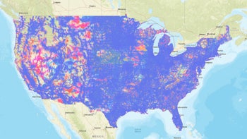
As 5G wireless services continue to slowly but steadily expand and improve across the nation, the overwhelming majority of US-based mobile phone users can reasonably expect to acquire a good old fashioned 4G LTE signal pretty much anywhere these days.
The difference between "pretty much anywhere" and "literally anywhere" can be incredibly significant, though, which is why we're excited to see the Federal Communications Commission (FCC) roll out a comprehensive and (purportedly) "truly accurate" 4G LTE mobile coverage mapat last.
Believe it or not, this is the first such map ever produced by the FCC, which in turn provides the "first ever standardized look" at 4G LTE mobile data and voice service availability nationwide... more than a decade after the 3G-replacing technology made its timid US (and global) debut.
In theory, the first-of-its-kind map, which looks almost surprisingly easy to use, load up, and navigate, should show you exactly where you can get reliable service on AT&T, T-Mobile, US Cellular, and Verizon, thus helping you make an informed decision when thinking of switching from an operator to another or simply relocating.
But the data itself might not be 100 percent accurate, having been submitted "voluntarily" by the four aforementioned carriers, at least three of which were found guilty of grossly misrepresenting their 4G LTE coverage not that long ago.
Still, being able to easily access one map in one place for all mobile network operators definitely beats searching for and manually comparing four other resources found on four different websites, some of which are not always as user-friendly as what you can find at this fcc.com link.
Speaking of the user experience, that includes separate layers (colored slightly differently) for LTE data and LTE voice service for each carrier, which you can zoom in on to view across a certain area or search by entering specific addresses.
Of course, your actual "on-the-ground" cellular experience may not coincide with what the FCC is listing here, which represents expected "outdoor" and "stationary" coverage instead of the speeds you might register indoors or in a moving vehicle.
Finally, while we're on the subject of speeds, it's important to point out that the map includes all of the places where you can realistically expect to squeeze at least 5 Mbps download numbers and 1 Mbps uploads out of your smartphone. Now let's just hope the FCC won't need another decade or so to develop a similar 5G tool.






Things that are NOT allowed: